


Ten Federal States

The Federal States of Bavaria, Berlin, Brandenburg, Hamburg, Mecklenburg-Western Pomerania, Lower Saxony, Saxony, Saxony-Anhalt, Schleswig-Holstein and Thuringia all belong to the Elbe River Basin. In cooperation with the German government they reached an agreement on how to jointly implement the EC Water Framework Directive (WFD) within the German section of the international Elbe River Basin District. To this end, they founded the River Basin Community (RBC) Elbe on March 4, 2004 with the objective of ensuring that the planning of the water management and the program of measures are carried out jointly in terms of methodology and content. The River Basin Community Elbe coordinates the implementation of both the WFD and the Floods Directive (FD).
Five Coordinating Areas
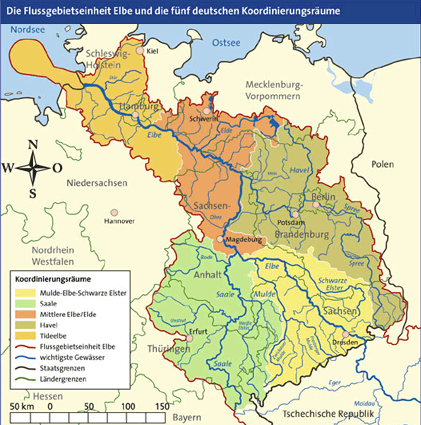
In compliance with the Water Framework Directive, the ten Federal States identified five coordinating areas (= sub basins) for the river Elbe. These areas do not follow the Federal States' borders but the natural network of Elbe tributaries. The five coordinating areas constitute the German sub basins for water management measures for the river Elbe.
The areas are:
- Mulde-Elbe-Schwarze Elster
- Saale
- Middle Elbe/Elde
- Havel
- Tidal Elbe
In addition to the above-mentioned areas, smaller river basins exist in some border areas of certain German States and Czech Republic; these areas, however, are managed by Czech Republic.